Saturday, January 23, 2010

Side Trip - Old US 33 Alignment Benton/Ligonier


Click to see larger image
Signpost at south end of Old US 33 Alignment, looking north. Current US 33 visible on left, Old US 33 on right. Dave Zollinger photo.

In the period of time since the Lincoln Highway was originally laid out, the route was adjusted time and time again in order to make it shorter and more efficient. Some of these alignments occured while the route was still a major, active throughfare. Some are still taking place along the highways that once made up the route today.
Part way between Benton and Ligonier there is a short stretch of the old US 33 that has been bypassed by one of these alignments. This was once part of the original route of the Lincoln Highway.
To find it, follow these directions:
If you are coming from Goshen (north), follow US 33 (Lincoln Highway) south from Goshen, through Benton. From the intersection of US 33 & CR 33 at Benton, stay on US 33 and go 3.8 miles. The signpost shown in the photo will be on your left.
The entire drive is 11.5 miles from the Elkhart County Courthouse (center of Goshen)and will take 20 to 30 minutes depending on traffic.
If you are coming from Ligonier (south), follow Lincolnway West west from Ligonier. When you cross the county line from Noble County into Elkhart County the road name will change from Lincolnway West to CR 50. Keep going west until you get to the intersection of US 33 & CR 50. From the intersection of US 33 & CR 50 go north on US 33 for 0.3 miles. On the right you will see the road sign seen in the image above.

Click to see larger image
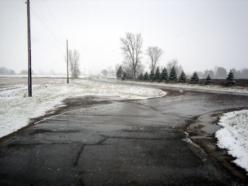
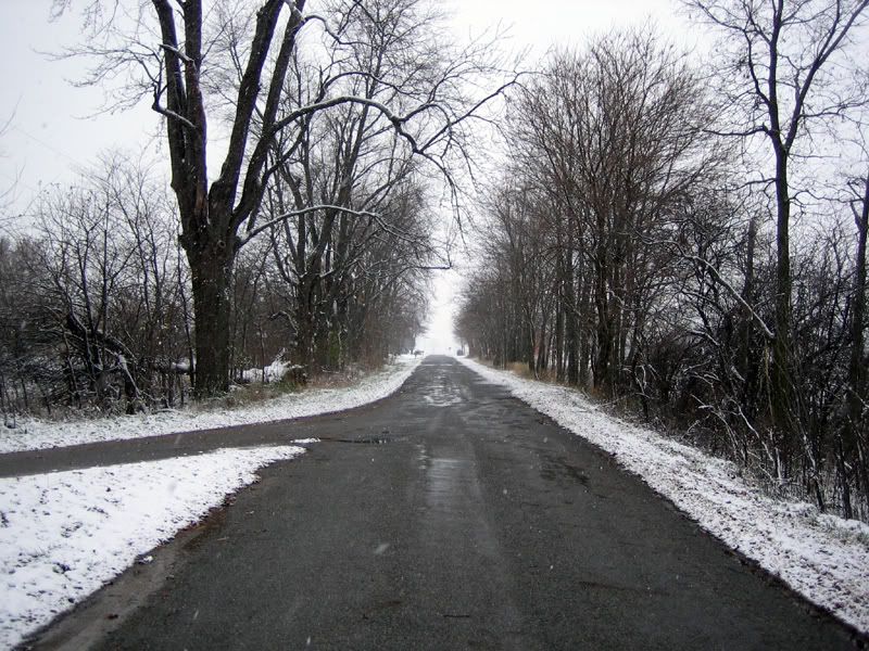
Looking south from roadsign. Current US 33 leads towards intersection of US 33 & CR 50 in the distance. Dave Zollinger photo.

Click to see larger image
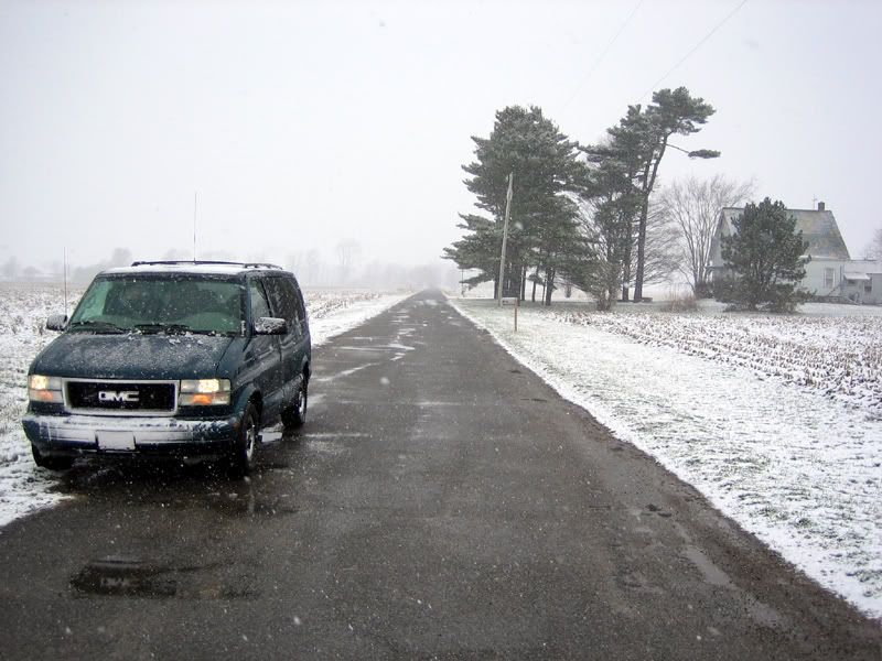
Looking north along Old US 33 from the same spot, the Spiny Norman Lincoln Highway Exploration Vehicle is clearly visible on the left. Dave Zollinger photo.

Click to see larger image
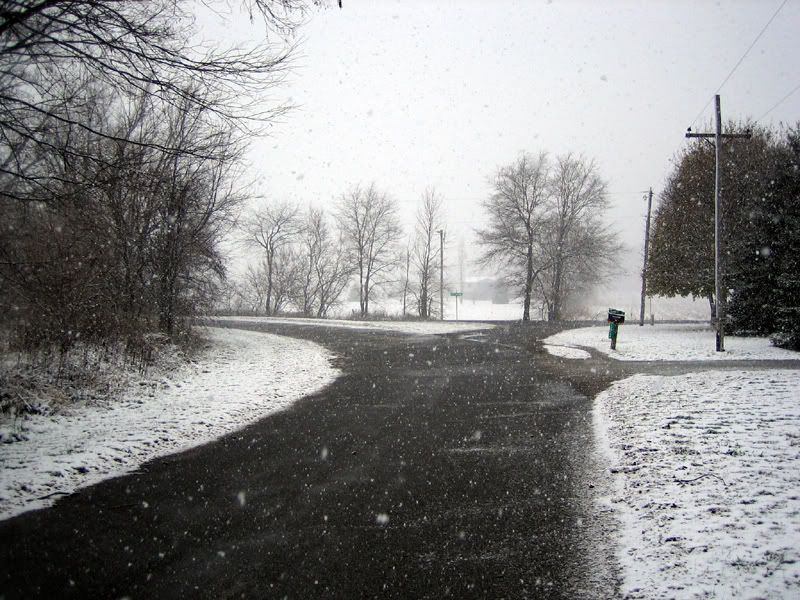
Further north, the road curves to the west and joins CR 148. Dave Zollinger photo.

Another 0.3 miles north of the roadsign, Old US 33 curves towrds the west and joins CR 148. From there it's about another 0.3 miles until CR 148 rejoins the current US 33.

Click to see larger image
Looking west on CR 148, past the curve, towards the current US 33. Dave Zollinger photo.

Map:


View Larger Map

Sunday, December 14, 2008

Goshen Police Booth


Click to see larger image
The old Goshen Police Booth. Located at the corner of Main St. (Lincoln Highway) & Lincoln Avenue. Dave Zollinger photo.

Right in the center of Goshen, in the Elkhart County Courthouse square, you'll find one of the town's more interesting buildings.
The Goshen Police Booth was built in the late 1930's to protect the city's two banks, which were located diagonally opposite of one another. At that time city officials had good reason to fear that auto bandits travelling the Lincoln Highway might strike Goshen. In 1933 members of the John Dillinger gang had raided police facilities in Auburn, Indiana, and Peru, Indiana, stealing several machine guns and other weapons, ammunition, and bulletproof vests. The gang later robbed a police station in nearby Warsaw, Indiana, of guns and bulletproof vests. In 1934 Dillinger and Pretty Boy Floyd robbed a bank in South Bend, Indiana, killing a law enforcement officer in the process. With Auburn located to the east of Goshen, Peru to the west, Warsaw to the south and South Bend to the north, it seemed likely that the Dillinger gang, and other gangsters of the day, were passing through Goshen while en route to commit their crimes.

Click to see larger image
The solidly built police booth has bullet proof windows with firing ports. Dave Zollinger photo.

John Dillinger, and most of the other infamous members of his gang, were already dead or in prison by the time that the Goshen Police Booth was completed in 1939. But that didn't stop the Goshen Police Department from putting their new facility to good use.

Click to see larger image
This photo, believed to be from the 1940s, shows local emergency service personnel and their vehicles posed in front of the police booth. The car on the right is from the Elkhart County Sheriff's Department, middle is from the Goshen Police Department, and ambulance is on the left. Ambulance crewmen may have been from local funeral home. Rectangular building in the left rear is a public restroom that no longer exists. Photo from archives of Goshen Historical Society.


The booth became the department's "front desk", so to speak, and was manned by an officer 24 hours a day. When a citizen wanted to make a report to the police they went to the booth, rather than a desk at the police station. This arrangement also meant that there was always an officer on duty in the city's central business district, watching over the downtown.

Click to see larger image
Goshen Police Officer shown manning the booth, year unknown. View through window appears to be looking east on E. Lincoln Avenue. Photo from Troyer Studio Collection, Goshen, Indiana.

Note: For more information on the old Motorola police radios shown in the above photo, follow this link: Motorola History - Early Police Radios
Thanks to my friend and fellow amateur radio operator Dave Menges WB9TEN for the information.

In earlier years when there was also an officer on foot patrol downtown, a system of call-lights was controlled from the police booth. When the officer in the booth needed to contact the officer on foot patrol he would turn on the call-lights and the foot patrol officer would know to call the booth. Later on a radio in the booth allowed the officer to stay in touch with patrol cars. The police booth was manned by officers of the department until about 1970.

Click to see larger image
Although most of the gangsters it was built to protect against were gone by 1939, the Goshen Police Booth provided useful service to the community for nearly 30 years. Dave Zollinger photo.

So even though the the gangsters that it was meant to protect against were mostly gone by the time it was finished in 1939, the Goshen Police Booth provided useful service to the community for nearly 30 years.
It's a unique part of Goshen, and it's history is tied directly to that of the Lincoln Highway.

For a map to the Goshen Police Booth use the one for the Elkhart County Courthouse. The booth is located at the southeast corner of the courthouse square.

Tuesday, December 2, 2008

Goshen's Lincoln Highway 1915


Click to see larger image
Postcard shows view looking north on Main Street (Lincoln Highway) in 1915. Courtesy of Goshen Historical Society.

The image shown above is a scan of an old postcard from the collection of the Goshen Historical Society. It shows a view looking north on Main Street, which was the route of the Lincoln Highway, from Jefferson Street.
It is interesting to see that the card makes a point of featuring the Interurban trolley, with the tracks running down the center of Main Street. The brick construction of the Lincoln Highway is also clearly visible.
The postcard does not show an actual date that the photo was taken, but the stamp was cancelled in 1915.
The image below is a similar view showing the same location in the winter of 2008.

Click to see larger image
A similar view to the postcard above, taken in the winter of 2008. Dave Zollinger photo.

Monday, December 1, 2008

Goshen Historical Society


Click to see larger image
The Goshen Historical Society Museum. Dave Zollinger photo.

Goshen has a very active historical society. That society maintains a fine museum in the former Adams store at 124 S. Main Street, which is along the route of the Lincoln Highway.

Click to see larger image
The museum is located in the former Adams Store. Dave Zollinger photo.

The Adams store building was constructed in 1888 as part of the Harper Block. C.G. Adams & Sons opened their "jewelry & gent's furnishing store" in 1901. When it closed in 1997 the store had been owned and operated by members of the Adams family for the entire length of time. Pauline (Polly) Adams was the last, and I can remember visiting Polly at the Adams store to buy Boy Scout uniforms when I was a youngster.

Click to see larger image
This old photo shows the store that now houses the Goshen Historical Society museum. It's the one with lettering on the awning, directly behind the buggy. Photo courtesy of Goshen Historical Society.

Since the Goshen Historical Society bought the building in 1998 it has been the subject of major improvements to it's infrastructure and exterior. Some remodeling has been done as well.

Click to see larger image
The beautiful old building makes a fine place to house the museum. Dave Zollinger photo.

The museum is used to display artifacts that were made or in some way pertain to Goshen. Many donations of such items have been made by Goshen residents. Currently the museum is open every Saturday from 10AM to 1PM and is staffed by Goshen Historical Society members.

Click to see larger image
The museum holds a large collection of artifacts relating to Goshen's history. Dave Zollinger photo.


The Goshen Historical Society museum is easy to find. Located right along the Lincoln Highway at 124 S. Main Street, it's just two doors south of Sorg Jewelers.

Contact:
The Goshen Historical Society
"The Adams Store"
124 S. Main Street
Goshen, IN 46526
574-975-0033

Saturday, November 29, 2008

Goshen's Carnegie Library


Click to see larger image
Goshen's Carnegie Library was the first one in Indiana. Dave Zollinger photo.

Goshen has a Carnegie Library, as do many towns do. But Goshen has the distinction of of having the first Carnegie Library that was built in the State of Indiana.
Located at the corner of 5th & Washington Streets, the classic building now serves as Goshen's City Hall. The current Goshen Public Library is now located about four blocks to the south at the corner of 5th & Purl Streets.

Click to see larger image
Historical marker at Goshen's Carnegie Library. Dave Zollinger photo.
Text reads:
Side one:
Indiana's first Carnegie library opened here 1903 with 3, 000 volumes. Goshen Library Association received $25, 000 in Carnegie grants 1901. Public donations, land purchase, and tax levy met Carnegie grant conditions. Architects Patton & Miller, Chicago, designed Beaux-Arts style structure. Library moved 1968; commercial and nonprofit uses followed.
Side two:
Listed in National Register of Historic Places 1983. Renovated building reopened 2001housing city offices. Original features of decorative marble, fireplaces, and domed rotunda retained. One of 1, 679 libraries built in U.S. with funds from philanthropist Andrew Carnegie. Indiana built more Carnegie libraries than any other state.

For travellers following the Lincoln Highway through Goshen, a visit to the building will require a detour of only 1 block from Lincoln Highway Route (Main Street).

Click to see larger image
Goshen's Carnegie Library, originally opened to the public in 1903, now serves as Goshen's City Hall. Dave Zollinger photo.

Click to see larger image
A scan of an old post card from the collection of the Goshen Historical Society showing the Goshen Carnegie Library. Date that the photo was taken is unknown. Postcard has a stamp cancellation date of 1912. Courtesy of the Goshen Historical Society.

Map to Goshen's Carnegie Library:


View Larger Map

Thursday, November 20, 2008

Fort Beane


When you're exploring Goshen on the Lincoln Highway there are quite a few things that you're going to want to visit while you're downtown. The west side of town has it's share too. But when you're following Lincolnway East there aren't a whole lot of things to see. Unless, of course, you enjoy looking at Wal-Mart, Arby's, Menards, and all the rest of the modern landscape.
However there is one very interesting part of Goshen's history for you to visit while you're on the east side, and it's located right on the Lincoln Highway.
Many people who live here drive by the Fort Beane marker day after day and never give it a thought. I am amazed at the number of local people who say, "I always wondered what that was!" when I mention the memorial. Others tell me that they've never even noticed it.
Since you are one of the very, very, few people who read anything on this site, you'll not only know what the marker is all about, you'll know where to find it too.
Exciting, isn't it? Kind of like being in an exclusive club.

Click to see larger image
The Fort Beane monument. Located on the west side of Lincolnway East, between Reynolds Street and 15th Street. Dave Zollinger photo.

The story of Fort Beane is an interesting part of Goshen history. Like many area communities, Goshen raised a militia during "The Black Hawk War" in 1832. The citizens of Goshen were afraid that Chief Black Hawk and his band would leave Illinois and pass through this area since they were known to have relations nearby in Michigan. The Goshen Militia Company eventually decided to build a fort near the road that led to Benton (and on to Ft. Wayne) and named the fort in honor of their Captain, Henry Beane.
According to the histories that I have read, construction on Fort Beane was halted shortly after it started and never got much further than a few log palisades.
The road that the old fort was constructed beside eventually became the Lincoln Highway.

Learn more about The Black Hawk War:
Black Hawk War at Wikipedia
Black Hawk War of 1832

Click to see larger image
Closer view of the inscription on the Fort Beane marker. Dave Zollinger photo.

If you decide to visit the Fort Beane marker, a word of caution. Traffic on Lincolnway East is usually very heavy in this area. You would do well to park somewhere west of the monument on Reynolds Street in the residential area and walk to the stone.

Click to see larger image
View of Fort Beane marker taken from E. Reynolds St. Looking SE towards 15th St. Dave Zollinger photo.

Map to Fort Beane marker:


View Larger Map

Tuesday, November 18, 2008

Elkhart County Courthouse


Goshen is the county seat of Elkhart County, Indiana. Although the city of Elkhart is considerably larger than Goshen, the latter was probably named the county seat because of it's central location within the county.

Click to see larger image
View of the Elkhart County Courthouse, Fall 2008. Looking towards the northwest from the intersecton of Main & Lincoln. Dave Zollinger photo.

The Elkhart County Courthouse stands in the center of town, at the intersection of Main Street & Lincoln Avenue. In this particular part of town Main Street is the route of the Lincoln Highway.
The courthouse is a beautiful structure in it's own right. But the grounds also hold the Neptune Fountain (which I did not photograph because it was already sealed up for the winter), and the county war memorial.
Because of it's central location the courthouse is a good place to park and explore downtown Goshen. It's within easy walking distance of the Olympia Candy Kitchen, Sorg Jewelers, the former site of the Alderman Hotel, the old Goshen Police Booth, the Goshen Antique Mall, and a score of stores, coffee shops, and historical buildings.

Click to see larger image
Historical marker at the Elkhart County Courthouse. Dave Zollinger photo.
Inscription on Marker Reads:
Side one:
Elkhart County was formed by the Indiana General Assembly 1830; the first county seat was located in Concord Township. County commissioners relocated the county seat to Goshen 1831. Jacob Studebaker, Goshen, designed first brick courthouse, completed 1833. Barrows and Garnsey, Chicago, designed second brick courthouse, completed 1870.
Side two:
Patton and Miller, Chicago, redesigned and enlarged Renaissance Revival style structure, completed 1909. Contractor, P. H. McCormick, Columbus, dismantled south end tower and dome, added north and south wings, and built new central dome and tower incorporating original 1870 clock. Listed in National Register of Historic Places 1980.

The Elkhart County Courthouse is a Goshen landmark, and it's located right on the route of the Lincoln Highway.

Click to see larger image
Elkhart County Courthouse as photographed in 1970. View is same direction as my photo above. Photo by Calvin Beale.

Click to see larger image
View of the courthouse under construction in 1908. Photo believed to be public domain.

Map:


View Larger Map

Don't Be A Victim! Know Your Lincolns!


What's the name of that road? Lincoln Highway? Lincolnway? Lincoln Avenue? Well in Goshen, Indiana it might be any of the above. Confusing?
Worse yet, many people who live here don't seem to know the difference. So if you use the word "Lincoln" when asking for directions, you may get directions to the wrong place.

In an effort to make your visit to Goshen a little bit easier, we offer the following:

Lincoln Highway
The Lincoln Highway generally follows US Highway 33 through town, although it leaves the highway on the west side. It is well marked with Red, White & Blue "L" signs. One of my goals for this site is to provide detailed driving directions, with maps and photos, for following the route through town. Some day. However, I don't know when I'm going to get that accomplished.
In my experience, most Goshen residents under the age of 50 don't have a clue what the Lincoln Highway is or where to find it. Many above age 50 don't either.

Lincolnway East
As US 33 meanders through town it has several different local street names. But from the junction where it curves into Madison Street near the high school, on to the city limits, US 33 is known as "Lincolnway East". That's the official Goshen street name for this stretch of US 33. Remember, when a Goshen resident uses the term "Lincolnway" they are only talking about this one stretch of US 33 on the east side of town, not the whole Lincoln Highway.
Worse yet, the name "Lincolnway East" seems to have fallen out of the common vernacular of late with many Goshen residents calling this stretch of road "US 33 East" or something similar. Sometimes when you are speaking to someone about Lincolnway East, they think that you are talking about East Lincoln Avenue (see below).

Lincoln Avenue
Goshen has a main north/south thoroughfare that divides the town into it's east and west sections. That road is State Road 15, also known as Main Street.
Goshen also has a main east/west thoroughfare that divides the town into it's north and south sections. That road is Lincoln Avenue. The eastern section of Lincoln Avenue is also designated as State Road 4.
These two streets cross each other at the "main" downtown intersection that most people consider to be the center of town, right by the courthouse. (Interestingly, at this particular point, Main Street is part of the route of the Lincoln Highway. So at the intersection of Main & Lincoln we have the Lincoln Highway intersecting with Lincoln Avenue.)
A map of Goshen from 1852 shows that the current "Lincoln Avenue" was once known as "Market Street".

Click to see larger image
Map of Goshen from 1852. Note "Market Street" designation for what is now called "Lincoln Avenue".

Since this map was published prior to the assassination of President Abraham Lincoln, my guess is that the citizens of Goshen later renamed Market Street in honor of the late president. However this is just conjecture at the time of this writing. I am attempting to track down official records to find out when the name of the street was changed and why.
Regardless, Lincoln Avenue has nothing whatever to do with the Lincoln Highway. It's a completely different street. But if you ask directions to the "Lincoln Highway" most Goshen residents are going to send you to Lincoln Avenue because it's the only Lincoln that most of them know.

Don't be a victim! When you're travelling through Goshen, know your Lincolns!